- 616.531.3660
- info@exxelengineering.com
- 616.531.3660
- info@exxelengineering.com
- 616.531.3660
- info@exxelengineering.com
- 616.531.3660
- info@exxelengineering.com
- 616.531.3660
- info@exxelengineering.com
- 616.531.3660
- info@exxelengineering.com
- 616.531.3660
- info@exxelengineering.com
- 616.531.3660
- info@exxelengineering.com
- 616.531.3660
- info@exxelengineering.com
Property Boundary Surveys
Whether constructing a new fence in your backyard or staking a large tract of land, we can provide the office calculations and the field work to stake out the boundaries of your property on the ground. We also verify that the boundary corners match the legal description of the property, locate any encroachments across the property lines, and prepare a certified survey map.
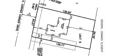
Mortgage Surveys/Reports
When you are selling or buying a home, a mortgage survey or report is often required to close the deal. A mortgage survey includes staking the property corners, accurate location of the buildings, drives, fences and other onsite improvements, any encroachments on the property and a survey map. A mortgage report includes the approximate location of the building(s) on the property and a sketch showing the location.
ALTA Surveys
For commercial and industrial properties, ALTA surveys are the industry standard. EXXEL has been providing ALTA surveys since 1985, when the standards were introduced. From small, 1-acre properties to much larger sites, EXXEL has completed literally thousands of ALTA surveys in West Michigan and throughout the state. We will work with you to customize the ALTA requirements to meet the need for your specific property.
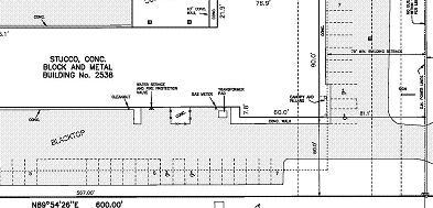
Topographical Surveys
An important tool in the design of a project is a topographical survey. These surveys show the elevations and contours of the existing ground, the utilities within or available to serve the site, and other features such as drainage, existing wooded areas or individual tree locations, and other onsite improvements. The topographical maps are drafted in CAD, and electronic files are provided as well as the paper prints.
Legal Descriptions
An accurate legal description is vital in conveying property and marking the boundaries of the property. We review the legal description of each property we survey to ensure its accuracy and completeness. We also work closely with title companies to resolve any discrepancies between descriptions of record and to perpetuate accurate legal descriptions.
Flood Plain Certifications
Recent changes in flood insurance requirements have made certifications essential in reducing or eliminating flood insurance for homes or businesses. Our survey department can provide FEMA elevation certificates or LOMA applications as required by lenders or flood insurance providers.
We also are able to provide both small or large scale cross sections of rivers for flood plain analysis and determination by local authorities or FEMA projects.
Construction Staking
Experience makes a difference in many areas, and construction staking is one of the most critical! Our field crew chiefs have an average of 15 to 25 years of on-the-job experience! We have the right equipment for the job also, from electronic total stations and data collectors, to robotic and GPS equipment. So, whether your project is a small commercial site, a large industrial or retail complex, or a high-rise building, we have the experience and the equipment to stake it correctly and efficiently.
FEMA/LOMA FAQ
Why am I being required to buy Flood Insurance?
Lenders want to protect their investments. Lenders will require flood insurance if the Federal Emergency Management Agency (FEMA) indentifies your property as being in the floodplain. Flood insurance costs vary. Contact an insurance agent to determine the annual cost.
How can I get my house removed from the mapped floodplain?
FEMA develops its map using the best information that it has available. FEMA also recognizes that sometimes its mapping does not reflect what a survey would detail. The process of correcting a map is called a ;“Letter of Map Amendment”; (LOMA). A Professional Engineer or Surveyor must certify that the structure (home) or property is not in the floodplain. The certification can be submitted electronically through the eLOMA process. If fill is required to raise the structure or property, then a “Letter of Map Revision” (LOMR) is required. Flood insurance will not be required by FEMA if a LOMA or LOMR is submitted and approved by FEMA. However, check with your lender regarding its requirements.
What Will This Cost?
Each property needs to be analyzed individually because the processing is not the same for all situations. A LOMA-Property Removal requires a sketch and description of the property removed from the flood hazard area. The advantage is any addition to the home or attached deck in the area removed will not require a second certification. A quote can be provided once the specific site is reviewed. If a group of homes in a neighborhood are surveyed at the same time, the cost will be reduced.
Who should I contact?
Robb Lamer, PE
(616) 531-3660 Ext. 114
rlamer@exxelengineering.com
Cameron Lear, PS
(616) 531-3660 Ext. 157
clear@exxelengineering.com
Surveying FAQ
What is the difference between a Mortgage Survey and Mortgage Report?
Mortgage Survey
- Required by a lender to show the existing features on a lot or parcel such as buildings, drives, walks, fences, decks, and other improvements.
- References buildings with distances to property lines and also show encroachments.
Mortgage Report
- An opinion survey showing structures with no reference to property lines
- Not intended to reflect precise boundary determinations.
I’m buying/selling a house. Will I need to get a survey?
It is up to the lenders involved in the transaction if a survey is required. Sometimes the property will have already been surveyed and a new survey will not be needed. Check with your lender or real estate agent.
Why do I need a surveyor to stake out my house when I build?
Cities and Townships have ordinances that require houses and out buildings to be a minimum distance from property lines. To make sure your house meets the setback distances, it is a good idea to have us stake it out accurately before digging for the footings. Some municipalities require a location survey showing the "as-built" location of the foundation.
I want to determine the location of my property lines. What can EXXEL do?
Our surveyors can accurately determine property corners and property lines from information derived from plat maps and legal descriptions. Typically we put wood stakes right on the property lines at a close enough interval to see between the stakes so you can easily see where the line is. Taking pictures of your line with the stakes in the ground is a good idea for future reference. Exxel has been surveying plats in the West Michigan area since 1972, there is a good chance we’ve been in your neighborhood!
My neighbor's tree is hanging over the property line. May I cut it?
We encourage everyone to get along with their neighbors and come to an agreement on trimming landscaping. We are able to stake property lines clearly but unable to provide legal advice. Please seek the counsel of a trusted lawyer.
I see a stake in my yard. What does it mean?
Most stakes you’ll see by a house are either on a property line, easement line or Right-of-Way and should be labeled in some way. Sometimes you might find a stake where there is no property line – the stake is usually for a “reference point” where we set up our instrument in order to see around trees or obstructions. If you see a number like "TP #50" on a wooden stake, it is a reference point. Property corners are usually a piece of 1/2" rebar with a plastic cap. Please do not disturb it!
 Yellow caps are typically property corners or property line markers
 Red caps are reference points and are not used for property corners
How close to a property line can I put a fence?
Each City and Township may have its own requirements for where fences should be placed. Call your municipality office.
I want to split my land into smaller parcels. What should I do first?
Your first call should be to your local municipality to find out the requirements for parcel divisions. Before land can be divided, it must comply with the zoning requirements for acreage, road frontage, lot dimensions, and access. Our survey department can then help you determine your options and provide new legal descriptions for the parcel split along with a staked survey of the new property corners.
What is a MBO?
On most lots in a subdivision, a house must be built high enough to avoid problems with drain water or high enough to have gravity fall for the sanitary lateral. A MBO is the Minimum Building Opening elevation. For a walk-out basement, the basement floor would be the lowest opening for the house. For a view-out basement, the lowest window sill is the lowest opening which must be higher than the MBO elevation to meet the requirement.
Surveying Services